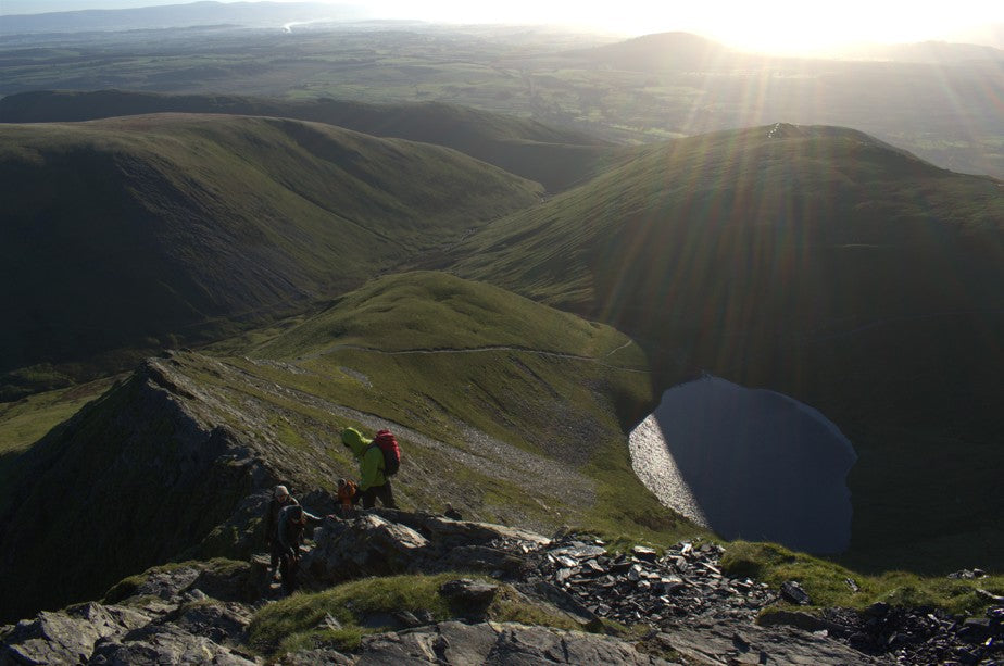
Blencathra, sometimes dubbed “Saddleback,” is one of the Lake District’s most iconic fells and this route is one of the finest ways to experience it. Starting from Scales, this circular hike offers a thrilling ascent via the legendary Sharp Edge, a narrow ridge that provides just the right balance of challenge and excitement for experienced hillwalkers. After reaching the summit, the descent via Hall’s Fell Ridge delivers a scenic ridge walk directly from the summit cairn tapering down toward the valley below. This route has it all; spectacular views, exposed scrambling and lots of adventure. Check out all the route details and download the map below.
At a Glance
Difficulty: Difficult - exposed scrambling requiring the use of hands, confident route finding, foot placement and a head for heights needed on both ridges
Distance: 8km/5 miles
Total Ascent:755m
Est Time: 4.5 hrs (not including rest stops)
Starting location: Free parking in multiple laybys on the A66
Facilities: The White Horse pub has meals, toilets and a beer garden
Dog friendly: Not advisable on the ridges
Blencathra Circular Route via Sharp Edge and Hall’s Fell
Scales to Scales Tarn
The route starts alongside The White Horse pub, where there is a steep (and slippery) path up a grassy bank that leads you to the main footpath. Follow the path to the right as it winds up towards Blencathra and Scales Tarn. The path here gains height gradually with one steeper section. There are a few options for paths here so some navigation will go a long way to make sure you’re on the right one. However, the paths lead in generally the same direction; cutting off uphill sooner will bring you out above Scales Tarn and following it round will lead you close to Scales Beck and will bring you right out at the tarn and the start of the climb up to Sharp Edge.
 Scales Beck sits beneath Sharp Edge in a classic glacial corrie. This is a great place to take your first break, enjoy a snack and to look up at the challenge ahead; Sharp Edge.
Scrambling on Sharp Edge

From Scales Tarn, Sharp Edge can look like an impossible monster. The way it curves dramatically makes it tricky to see an obvious route up when you’re below it but there is a well worn route to follow once you’re on the ridge. It’s one of the most iconic Grade 1 scrambles in the Lake District but it shouldn’t be taken lightly. Every year, people are rescued or worse on Sharp Edge so this is only one to consider if you have some Grade 1 scrambling practise. I also like to save it for a warm, dry and calm weather day because the polished rocks become like an ice sheet in wet weather and high winds can make this ridge treacherous to cross. If in doubt, go with someone who is experienced and confidence or hire a guide to take you.

Stick to the crest of the ridge where possible and follow the worn path and natural holds. You’ll find yourself having to use your hands for balance in places and the crux of the ridge is a short but awkward slab near the end. The drop here is significant so take your time. Just before the end of the ridge there is a chimney section which involves an up-climb using your hands and looking for good foot placements. It’s only short and a few minutes later you’ll find yourself at the top of the ridge.

Sharp Edge to Blencathra Summit
Once you've topped out, you’re rewarded with a wide, grassy summit ridge with incredible 360-degree views. On a clear day, you can see Skiddaw and Helvellyn as well as the central fells and even across to the Pennines in the east. The path over to the summit of Blencathra is a wide, stony path.

The summit of Blencathra was originally marked with a concrete ring laid by Ordnance Survey in 1953. In 2018, this was stolen but a fundraising effort saw it replaced in 2019, luckily. Blencathra is unique in that its summit is almost on the very edge of the fell. If you stand at the summit ring, you’ll be looking straight down the next ridge: Hall’s Fell.
Descending Hall’s Fell down to the valley floor
From the summit ring, locate Hall’s Fell Ridge, which starts just a few steps away and runs directly north. There is a small stony path which will take you onto the top of the ridge and offers a spectacular descent. It’s still airy but much less exposed than Sharp Edge, with occasional hands-on sections and lots of jaw-dropping views down into the valley.

This is another Grade 1 scrambling route with some exposed sections and bypass paths along the way. Take your time descending as the ridge is steep in places and can be slippery in poor weather. Eventually, the ridge broadens and flattens as you reach gentler ground near Gategill Farm.

Walking back to Scales
Once you reach the valley bottom, follow the path left along the base of the fell. The track loops back toward Scales, passing fields, dry stone walls and wide-open views back up to the summit you’ve just conquered. The final stretch returns you to your starting point, ideally in time for a well-earned drink or meal at the White Horse Inn.

Blencathra Circular Route via Sharp Edge and Hall’s Fell
Download the Ordnance Survey route and map here.

-
Starting point at Scales from free layby parking on the A66
-
Scales Tarn - a great rest stop
-
The beginning of Sharp Edge
-
The summit of Blencathra and the beginning of Hall’s Fell Ridge
-
The return at the base of the valley
Komoot App
Have you ever tried Komoot? Komoot allows you to access routes planned by others or plan your own which you can then download to your phone to follow while you are out. Komoot is free to join and access and you can find the route for his walk here.
Is there public transport to Blencathra?
There is no public transport option to Scales to hike Blencathra. The closest bus stop is at Threkeld which would then involve a 35-40 minute walk to Scales to start the hike. Stagecoach buses X4 and X5 stop at Threkeld. Click here for more information on the bus times.
How hard is Sharp Edge and Hall’s Fell Ridge?
Sharp Edge is a narrow ridge and a Grade 1 scramble. It requires the use of hands for balance but doesn’t need ropes or any technical climbing gear. It’s exposed, especially in the middle section, and can feel serious in poor weather or for those with a fear of heights. The rock can become very slippery when wet or icy so it's best tackled in dry, calm conditions by confident walkers with a head for heights. Hall’s Fell Ridge, while still steep and occasionally hands-on near the top, is less exposed and more straightforward making it a popular way to descend from the summit. Both routes should only be tackled if you have some Grade 1 scrambling experience, are confident with your current ability or if you are with someone who knows the route well and is experienced.
Grade 1 scramble tips and advice
A Grade 1 scramble in the UK is the entry level of scrambling — a middle ground between walking and climbing. You'll need to use your hands for balance and upward movement, but no ropes or technical equipment are required. That said, good judgement and steady footwork are essential, especially on exposed ridges like Sharp Edge as the consequences of a wrong move are high.
Top tips:
-
Use your hands – expect hands-on sections; gloves with grip can help like the My Urban Trail Mittens
-
Wear proper footwear – walking boots or trail shoes with good grip are ideal
-
Check the weather – avoid Sharp Edge in wet, windy, or icy conditions as the rock becomes incredibly slippery
-
Take your time – don’t rush; test every foothold and handhold
-
Know your limits – if you're uncomfortable with exposure, consider an easier route.Consider hiring a local guide if you are unsure and don’t be afraid to turn back if it all gets a little too much
For additional UK outdoor adventures, wild swimming, hiking routes and more, check my other blog posts here on MY URBAN TRAIL and follow me @Wild_0utdoors on Instagram.
Happy adventuring!
Izzy


